Webメルカトル地図画像取得
API名:
map_wm
概要:
Webメルカトル地図画像を取得します。
指定パラメータで地図画像を作成、サーバ側に画像を保存し画像のURLを返却します。
※Webメルカトル(EPSG:3857)に対応した地図を指します
URI:
https://test.core.its-mo.com/zmaps/api/apicore/core/v1_0/map_wm
<API使用例>
https://test.core.its-mo.com/zmaps/api/apicore/core/v1_0/map_wm?if_clientid=JSZxxxxxxxxxx|xxxxx&if_auth_type=ip&?size=600,450&latlon=35.65851,139.76015&zoom=12
リクエストパラメータ
地図画像用パラメータ
| パラメータ | 必須 | デフォルト値 | 説明 | ||||
|---|---|---|---|---|---|---|---|
| size | 600,450 |
画像サイズ
画像サイズを”横幅[ピクセル],縦幅[ピクセル]”指定します。
画像サイズの指定範囲は横幅、縦幅それぞれ 16[ピクセル]~3000[ピクセル]です。 最大幅は、scaleの設定値によって変わります。 例) scale=2(高解像度) ⇒ 16~1500 |
|||||
| latlon | 35.6644033,139.7560 |
緯度経度 取得したい地点の緯度経度を指定します。 ※同時に複数地点の緯度経度を指定することはできません。 ※世界測地系(WGS84)のみ指定できます。 |
|||||
| zoom | 12 |
地図倍率 表示するメルカトル地図の倍率を指定します。 |
|||||
| maptype | normal |
地図画像種別 取得したい地図画像の種類を指定します。
|
|||||
| imageformat | png |
画像フォーマット 画像を取得する時の画像フォーマットを指定します。 |
|||||
| sslcache | F |
地図画像データ暗号化指定 真偽値で指定します。 Tを指定すると地図画像をSSLを利用した暗号化通信で取得可能なURLを返却します。 |
|||||
| llunit | dec |
緯度経度形式 緯度経度形式を指定します。 |
|||||
| scale | 1 |
解像度 解像度を指定します。
|
重畳図形用パラメータ
| パラメータ | 必須 | デフォルト値 | 説明 |
|---|---|---|---|
| shape | - |
図形重畳データ
図形重畳データを指定します。
※設定できる緯度経度の測地系は、世界測地系(WGS84)のみとなります。 |
|
| adjust | T |
自動設定指定 重畳図形データ全体を表示できるように、地図の中心位置と倍率を自動設定するかどうかを真偽値で指定します。 Tを指定すると、自動設定します。 latlon, zoomを指定する場合はFを指定してください。 |
|
| adjsize | ※1 |
余白設定(絶対値指定) adjustにTを指定した場合、重畳図形を収める範囲を"横幅[ピクセル], 縦幅[ピクセル]"で指定します。 この指定を行うことで、余白の調整が行えます。 指定できる範囲は、横幅、縦幅それぞれ16[ピクセル]~3000[ピクセル]です。 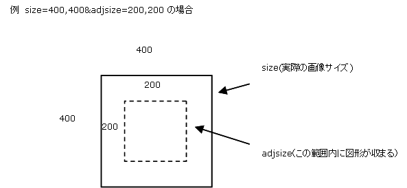 ※1 デフォルトの値はsizeパラメータで指定した値となります。 |
|
| adjsizesub | - |
余白設定(相対値指定) adjsizeと同じく余白の設定が行えますが、adjsizeと同時に指定することはできません。 adjsizeとの違いは、画像サイズからのマイナス値での指定を行う点です。 指定した値が、画像サイズを超える場合は無効となります。 指定できる範囲は、横幅、縦幅それぞれ0[ピクセル]~1500[ピクセル]です。 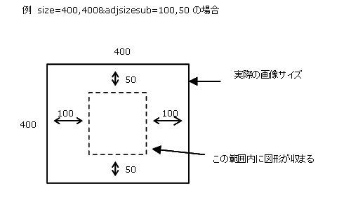
|
出力データ
出力フォーマット
{"map":{"width":600,
        "height":450,
        "center":{"lat":35.6644033,
                  "lon":139.756},
        "zoom":12,
        "bounds":{"sw":{"lat":35.6016278,
                        "lon":139.6530172},
                  "ne":{"lat":35.7271297,
                        "lon":139.8589828}},
        "scale":1},
 "imageUri":"https://core.its-mo.com/zmaps/api/pub/cache/f570350e94c579ca6b899af61accc4dd.png"}
| キー名 | データ型 | 説明 | |
|---|---|---|---|
| map | object | 地図情報が入ります。 | |
| width | number | 横幅が入ります。 | |
| height | number | 縦幅が入ります。 | |
| center | object | 中心緯度経度が入ります。 | |
| zoom | number | ズーム値が入ります。 | |
| bounds | object | 緯度経度矩形範囲が入ります。 | |
| scale | number | 解像度が入ります。 | |
| imageUri | string | 画像URLが入ります。 | |
出力例
[通常出力例]
https://test.core.its-mo.com/zmaps/api/apicore/core/v1_0/map_wm?if_clientid=JSZxxxxxxxxxx|xxxxx&if_auth_type=ip&size=600,450&latlon=35.65851,139.76015&zoom=12
{"map":{"width":600,
        "height":450,
        "center":{"lat":35.65851,
                  "lon":139.76015},
        "zoom":12,
        "bounds":{"sw":{"lat":35.5957297,
                        "lon":139.6571672},
                  "ne":{"lat":35.7212411,
                        "lon":139.8631328}},
        "scale":1},
 "imageUri":"http://test.core.its-mo.com/zmaps/api/pub/cache/f570350e94c579ca6b899af61accc4dd.png"}
[指定の緯度経度が地図の提供範囲外だった場合]
https://test.core.its-mo.com/zmaps/api/apicore/core/v1_0/map_wm?if_clientid=JSZxxxxxxxxxx|xxxxx&if_auth_type=ip&latlon=30.1,135.1
{"map":{"width":600,
        "height":450,
        "center":{"lat":30.1,
                  "lon":135.1},
        "zoom":12,
        "bounds":{"sw":{"lat":30.0331556,
                        "lon":134.9970172},
                  "ne":{"lat":30.1667992,
                        "lon":135.2029828}},
        "scale":1},
 "imageUri":null}